A blog by an historian, Pagan and fanfiction writer, with left-wing leaning politics. In short, I could be waffling on about anything.
Showing posts with label Great Wyrley. Show all posts

Friday, 23 December 2011

June's Memories of the Landywood Great Stones

Another of Great Wyrley's older residents has come forward to share her memories of the Landywood Great Stones. I am enjoying this trend, as oral history is invaluable in piecing together all these clues.

Like Mr Wiggin, June has lived in Great Wyrley all of her life. She enjoys a tipple in Harrisons Club, in Wharwell Lane, where she bumped into my father. He asked her if she recalled where the Great Stones once stood, and she did.

June told him that the larger stone, which currently sits outside Landywood Enterprise Park, was once opposite the school. She described a grassy island in which the stone stood alone. It surprised her to hear that there had been others too.

Her recollections dated from the 1940s. She said that, as the end of World War II was announced, the people of Wyrley gathered close to the lone Landywood Great Stone. They built a bonfire to celebrate and spent the night dancing in its light. There was a lovely party, born of relief and the end of the fighting.

June's memory of the stone chimes with that of Mr Wiggin. He had previously told my mother that 'they were opposite where Landywood Primary School now sits'. The only difference being that Mr Wiggin spoke of multiple stones, while June recalled just one.


View Larger Map
The view outside Landywood Primary School

Wednesday, 14 December 2011

Great Wyrley History: The Fighting Ground

In 1888, Queen Victoria was on the throne and Robert Cecil, Marquis of Salisbury, was running the country. The latter was causing controversy by stating that no 'black man' would ever be elected to represent a British Constituency. (He was referring to Dadabhai Naoroji, a man of Indian descent, who went on to be the MP for Finsbury Central.) The Oaths Act became law, removing 'God' from the oath of allegiance sworn by all MPs when entering Parliament, thus allowing Atheists to run the country. Jack the Ripper claimed his first victims in Whitechapel; the football league was formed; and a cartographer wandered through Great Wyrley making a map.

In the place where legend would have it that the Landywood Great Stones once stood, the cartographer wrote a label. This was, the map now stated, the position of the Fighting Ground. So what was the Fighting Ground?


Great Wyrley in the 19th Century

Today, Great Wyrley is a sprawling expanse of housing estates, hemmed in by the ruins of old mining works and the motorways leading anywhere else in the country. In the 19th century, it looked very different. It was smaller for a start, with clear divisions between Old Wyrley, Wyrley Bank, Landywood, Little Wyrley, Churchbridge and Cheslyn Hay.

The old men and women could still recall when all of this had been forest. Their own parents had made their living cutting the trees all down. The old timers had earned their bent backs and wrinkles in the shallow cut mines that sprung up once the charcoal had been cleared. There were deeper shafts being dug now, in places like Streets Lane and Gilpins down by Churchbridge.

In 1842, a law had been passed, which banned all women and children under ten from entering a mine. It meant that the black faces, hacking coughs from lungs filled with coal dust and the blue tattoos from cuts healing with coal dust in it, all belonged to the men. It also ushered in a new age of poverty, from families used to having far more wages. Kids as young as two could earn money down the mines, opening and closing doors.

Great Wyrley's Fighting Women and Gorse Bushes

Wyrley's women supplemented their family's income by collecting gorse from the moor and hillside edging Gorsey Lane. This could be burned as fuel, or crushed between rocks to feed livestock. The flowers were human food too, making a lovely salad or boiled as a tea. But there was a bigger trade to be had there.


Gorse is also called Broom for a good reason. The branches can be chopped into shape and gathered together to make a traditional broom. Wyrley women were frequently found in the markets of Wolverhampton, Walsall and Cannock selling their brooms. They earned a reputation for rowdiness and hard-faced bargaining there. They were forever causing fights.

The problem was so great that Frederick William Hackwood recorded the complaints of a Walsall police constable, in his The Chronicles of Cannock Chase (1903), about Wyrley women. It seemed that females caught fighting in half of the Black Country would be wont to give Wyrley Bank as their place of origin.

It was often just a convenient lie, because fighting women were expected to come from Wyrley. Most of them had never even seen the town, but they and the police knew that little could be done along that line of enquiry. No uniformed officer asking questions in Great Wyrley would find any answers. It was viewed as a den of iniquity, with the residents banding together against all comers and refusing to co-operate with the law.

It seemed that little had changed since the 12th century wardens of Edward III had reported back to their monarch that 'nothing can tame those wild Wyrley folk'. Even as late as 1888, there were no police officers in Great Wyrley. In 2011, there's still no police station.

The End of Bare-Knuckle Fighting in Victorian Britain

Great Wyrley, with its reputation and isolation, became a Mecca for sports that the law frowned upon elsewhere. Amongst these was bare-knuckle fighting, which settled feuds or simply pitted one hard man against another. It was illegal in 19th century Britain, with police officers entering the fray to break them up and arrest all participants.

The Marquis of Queensbury had tried to channel all of this aggression into a series of rules, which would ultimately result in the accepted sport of Boxing. But in 1867, when he introduced them, even boxing was afforded only a dubious legality.

The whole weight of the justice system was being thrown against bare-knuckle fighting, particularly when people were betting on the outcome. In 1882, the Court for Crown Cases Reserved made a judgement that is still law in Britain (R v Coney). The Crown Justice ruled illegal any fight resulting in actual bodily harm, even if both participants had given their prior consent. Anyone found spectating could also be charged with aiding and abetting.

This was pretty much the death knoll for locally organised bare-knuckle fighting throughout the country. But not in Great Wyrley.


The Fighting Ground in Landywood

The wide expanse of land was scarred with the remains of open cast mines and the shallow gulleys forged to drain water away. It had once been forest and off, on the far Southern horizon, there were still the few dotted trees that were now Essington Wood. This was the Fighting Ground.

Holly Lane looped around it, leading in one direction to the Wyrley-Essington canal, along which walkers could eventually reach Wolverhampton and Birmingham, and in the other to the fields backing onto the old Roman Watling Street. Run that way and you had a choice between North Wales or London and anywhere else between the two.

Not that anyone would have had to go to such extremes. Landywood was just a short sprint away from Wyrley Bank, where people could just disappear because no-one would have seen them at all. Especially when a police officer was asking.

To the immediate north-east was Broom Hill, with its sweeping view over endless acres of Staffordshire and maybe even as far as Shropshire. This was the place where the Parliamentary army had camped during the Civil War for precisely the same reason. You can see people coming from miles away. A shout from the top of Broom Hill could probably be heard from the Fighting Ground. A lit bonfire would certainly have been seen.

In short, the bare-knuckle fights went on with impunity. There were no police officers in Great Wyrley. If any were called, then the look out on top of Broom Hill would see them coming. In any case, it would take a long time for them to get there. They'd have to arrive from Cannock or Hednesford, which was a fair trek, even on horseback, and someone would have to get the message to them first.

But in the extremely unlikely event that police constables arrived on the scene in time to interrupt any fight, there were escape routes everywhere. The majority would probably have just run south, where there was no barrier between them and the distant Essington Wood. It would have been a short stroll back along the canal later.


There is oral history of this still in Great Wyrley. Steve, who we last met in the hunt for the Landywood Great Stones, had heard all about it. The story passed down to him was that prize fighters used to come from miles around - from the Black Country, from Staffordshire, from Shropshire, Birmingham and perhaps even further afield - because Great Wyrley was one of the safest places to fight, as regards the law.

Wednesday, 7 December 2011

Mr Wiggin's Memories of the Landywood Great Stones

My mother bumped into Mr Wiggin, who remembered when the Landywood Great Stones were on view in the town.

Mr Wiggin is an older man. He comes from a family which has been in Great Wyrley for generations. When my mother asked him about the Stones, he knew immediately what she was talking about. She asked where they were located and he replied that they were opposite where Landywood Primary School now sits. They were in The Gosse.

The Landywood Great Stones in The Gosse

This rang a bell with me. Returning to our old friends, James Homeshaw and Ralph Sambrook, there was a mention of the Old Gosse Field, just before they discussed the Landywood Great Stones:

'Wyrley grew through the centuries as the trees of the Cank Forest were cut down and the wastes were cultivated. Little remains now of the glory of the forest, but in the Old Gosse Field in Hazel Lane there is a copse of oak trees which, on a summer's day, give in miniature what the whole parish looked like in those days, when the Great Stones of Landywood stood overlooking the valley of Wyrley Brook, and constituted the temple of the Druids.'
EJ Homeshaw and R Sambrook, in A Plesance Great Wyrley 1051 - 1951.

However this does leave me with a slight problem: Hazel Lane is nowhere near Landywood Primary School.


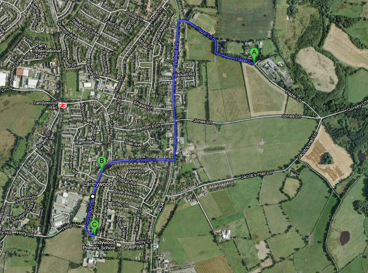
A = Hazel Lane, which is where Homeshaw and Sambrook placed the Old Gosse.
B = Poplar Road, which is where Steve and the 19th century maps placed the stones.
C = Landywood Primary School, in Holly Lane, opposite which Mr Wiggin placed both the Gosse and the Landywood Great Stones.

It should be remembered that each of these testimonies recall a time when none of the housing nor roads existed between B and C. When all four gentlemen were noting the position of the stones, they were looking out over a hill covered in gorse bushes, with fields beyond.

With his back to Landywood Primary School, Mr Wiggin could have seen the Great Stones in the distance opposite, if they were at the present day junction of Poplar Road and Gorsey Lane. Hazel Lane would have been too far away, with a hill obscuring the view, to be seen from there.

We are also assuming that 'opposite' means looking towards the Tower View estate on Broom Hill. There is, of course, a 360 degree view from that school. It is intriguing to note that the supposed pre-19th century position of the stones, in the Holly Lane loop, is also opposite Landywood School, if looking to the west.

My next priority is to a) discover the precise location of The Gosse; and b) track down Mr Wiggin and clarify the details that he told my Mum.

The Landywood Great Stones in the Muck Tip

Mr Wiggin's recollections didn't end with the Gosse. Mindful of the decade or so gap in my timeline, my mother asked him where the Landywood Great Stones went, after being moved from the Gosse.

He knew this one too and had an amusing story to add some colour. Before Landywood Enterprise Park was built, the site had been known locally as the Muck Tip. It was where the factory on Gorsey Lane dumped its waste, so a distinct slurry had formed there.

One night, Mr Wiggin and his brother had been to Blower's Club, in Holly Lane, with their grandmother. She was in a wheelchair. It was very dark, with just a gas lamp in the distance of Gorsey Lane to guide them. Perhaps it was the lack of night vision or maybe they'd partaken of a few too many beverages at the club, but they took a wrong turn. The merry group thought they were heading down Gorsey Lane, but they had really entered the Muck Tip.

Very soon, the front wheels of the chair hit something solid, propelling their old grandmother out of her wheelchair. She landed right in the slurry, plastered in the stuff. By all accounts, her grandsons were too busy laughing to immediately help her back into their chair. Fortunately for them, she also found the episode highly amusing. Filthy, but uninjured, she was eventually restored to her chair and the Wiggins found their way home again.

The relevance here is that this is where the Landywood Great Stones ended up too. Once they were removed from the Gosse, they were carted to the Muck Tip. There they presumably remained until Landywood Enterprise Park was built. One of them is still there, at the entrance as a decoration and curiosity. The rest were taken up the Streets Lane estate and either buried under Weston Drive or dumped at the side of Streets Lane itself.

A Recap of the Known Locations of the Landywood Great Stones

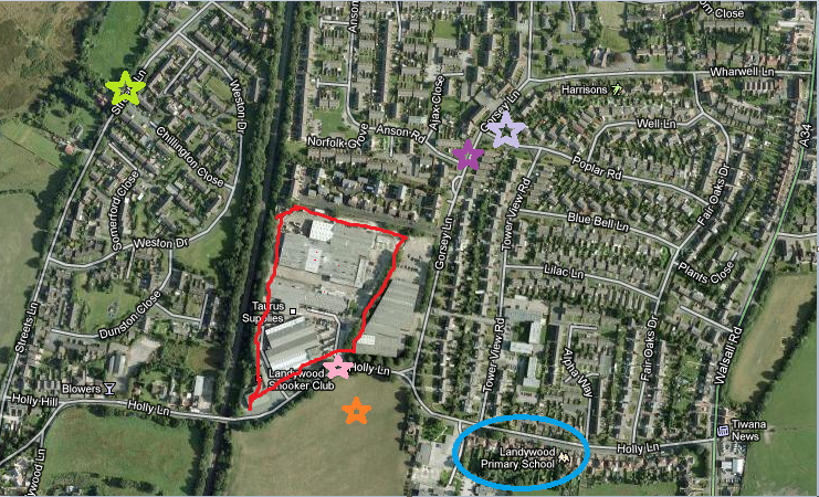
These stones moved around a lot, as industry, housing and businesses took priority of their sites. Here is a recap of where they are confirmed or suspected of historically being:

  • Orange Star: Their supposed original, pre-19th century position in the loop of Holly Lane. They would have been surrounded by the trees of Essington Forest then.
  • Lilac Star: Their position as shown on 19th century maps and remembered by Steve.
  • Blue Circle: Their 20th century position was 'opposite Landywood Primary School' located in The Gosse, as recalled by Mr Wiggin.
  • Red Bordered Area: In the mid-20th century, this would have been the Muck Tip. Mr Wiggin says that the Landywood Great Stones were briefly there. They were moved again, when construction started on the Enterprise Park in 1982.
  • Pink Star: The position of one of the stones, which is still there today. It would have been placed there circa 1985, when Princess Diana came to open Landywood Enterprise Park.
  • Lime Green Star: The place where I believe that remainder of the Great Stones were dumped. Cllr Kath Williams alternatively heard that the stones were buried under Weston Drive, which is close to that location.
  • Purple Star:  The position of the stones, in the ditch just north of where Anson Road meets Gorsey Lane, as told by Ruination in the comments to this blog.

I will share more information about the Landywood Great Stones as I learn it.

Sunday, 4 December 2011

What Were the Landywood Great Stones?

'... the Great Stones of Landywood stood overlooking the valley of Wyrley Brook, and constituted the temple of the Druids.'
EJ Homeshaw and Ralph Sambrook Great Wyrley 1051 - 1951.

When two local historians wrote those words in 1951, they must have been dreaming of an idyllic, romantic past for Landywood and Great Wyrley. The imagination feeds the rest of the details.

The Herculean effort involved, over several generations, for a community to drag stones from distant places into the heart of their town. We envisage long, arduous quests for the quarry. The chipping away of huge boulders from solid outcrops. The floating, dragging, inching along of the standing stones into their present position. The pride of a people encapsulated in the rising religion of Druidry, wherein these rocks became altars and the megaliths the cathedrals of their day.

Unfortunately for Great Wyrley, this doesn't seem to have happened there at all. But the reality is probably much more dramatic than that.


Ancient Britain: A Mile High Wall of Ice

Imagine a cliff-face of ice. A great glacier that rises higher than Ben Nevis or Snowdon. Now you have that peak set into your mind, picture flying above it. It's not a single mountain here, it's a vast plateau extending as far as the eye can see. Nothing but ice, glistening in the frozen air, reflecting sunlight that warms only to -8 degrees Celsius (17.5 degrees Fahrenheit) in the heat of noon. Then drops to much, much colder temperatures when night falls.

Britain has been subject to several Ice Ages in its ancient history. (Though a mini Ice Age is being predicted for winter 2011.) The biggest of all saw most of England, Wales and Ireland covered in a mile high glacier. Scotland was lost completely beneath it.

Just south of the Midlands was the vast cliff-face that you just formed in your mind's eye. It didn't end at the modern coastline. The oceans were so bound up in ice that it would have been possible to walk across a periliously cold tuntra into today's Netherlands or France. There was no North Sea. There was no English Channel. They were both frozen wastegrounds, in which nothing could easily survive.

Then the ice melted.

Ancient Britain: The Great Flood

Some believe that the story of Noah and the great Biblical flood stems from a folk memory of the melting of an Ice Age. There would certainly have been people on Earth (the last one was only 10,000 years ago, with the biggie just a couple of thousand years before that).

Melt an ice cube on a plate, or leave the freezer door open so that it defrosts, then look at the amount of water that is left. Now scale up and keep on scaling up, until your mind can see the sheer volume of water that once rushed across Britain. If that fails you, then wander down to the seaside. Look at the North Sea. Look at the English Channel. Look at the Irish Sea, the Celtic Sea and St George's Channel. Now can you grasp the level of water that melted?

The North Sea


There was the roar of a tsunami across the tundras. Britain became an island, cut off from the rest of Europe. Valleys were carved out of the landscape. The soil and bedrocks were ground and crushed beneath it. Like a seesaw, the country is still trying to rectify its levels. A lot of heavy ice melted off the top of the mainland British Isles. Even today, Scotland is very slowly rising and London, along with the rest of the south of England, is gradually sinking.

Drop a twig into a stream and see how the water carries it along. Now scale up again. This was the sort of great deluge that carried trees. Watch how a wave scrapes pebbles on a beach back into its depths. Scale up again. The melting ice dragged boulders from the mountain side and took them halfway across the country.

Ice Age Rocks Scattered Across the Landscape

In 1903, a gentleman named Frederick William Hackwood was commissioned by the Lichfield 'Mercury' Office to write a history of the area. It was eventually published as The Chronicles of Cannock Chase. Now out of print, it can still in found in local history centres and libraries. He didn't start with human history, but with the creation of the Staffordshire landscape itself.

One of the major curiosities of the county were the large amount of substantial rocks lying around. They were strewn east of Cannock Chase, in a wide arc that included half of the Black Country. Moreover, they were not indigenious to the area. Geologists had traced their origin to two locations - West Wales and the English Lake District. More specifically Arenig in Gwynedd and between the Ravenglass and Mayport hills in Cumbria.

An example of one of these is in the Walsall Arboretum; another stands in Wolverhampton's West Park. They were brought here in a torrent of water, at the melting of an Ice Age. These orphaned rocks are called erratics.

Great Wyrley and Landywood both sit smack bang in the centre of this plain of erratics.

Is There Any Evidence of Erratics in Great Wyrley and Landywood?

In a previous blog entry, I mentioned that Paul Ford (Walsall Local History Centre) had contacted me about my quest to find the Landywood Great Stones. He and I had both, independently, concluded that this was no desecrated stone circle, but erratics in Wyrley.

Paul Ford found a mention of such rocks in HG Mantle's 'Glacial Boulders East of Cannock Chase', a book written in 1897. It was the same study quoted by Hackwood, in his history of the area. Mantle had observed, 'On both sides of the road between Gt Wyrley Railway Station and Brownhills... there is a constant occurrence of erratic blocks varying from an inch or two, to several feet. Roadside heaps consist of the most part of erratics... as do stones in the turf and arable fields.'

Neither Mantle nor Hackwood talked about any 'temple of the Druids', as Homeshaw and Sambrook had fancied.


Erratics Used in Creating the A34/Walsall Road

In 2000, the Great Wyrley Millennium Committee produced a book as part of its 'welcome to the 21st century' celebrations. It was comprised of five chapters, charting Wyrley's history, buildings, organisations, the entire 20th century and its future. Many older residents had been interviewed and their stories were told. Amongst them was Mr H Rowley, whose father had been the road surveyor responsible for 11 miles of the A34, as it passed through Great Wyrley.

He wrote about how the Walsall Road, as it's known locally, was just a muddy trackway at the start of the 20th century. Under his father's supervision, it was turned into a roadway suitable for traffic, but that involved a lot of labour and materials. A temporary stone works was established opposite the Star Inn, where a Mr Hanson oversaw the cracking of rocks for use in the road.

Mr Rowley went on to write, 'Stones were plentiful in Great Wyrley, relics of the Ice Age when the granite hills of Wales and Cumberland were perpetually covered with snow and ice which moved southwards in the form of huge glaciers, carrying masses of granite to the Midlands. Many of these were saved by the British and Saxon settlers as boundary stones.' (pg 55, Great Wyrley Millennium Souvenir)

This would have sounded suspiciously like the Landywood Great Stones anyway, as Holly Lane once constituted the border between Essington and Wyrley, but Mr Rowley had something more to add.

As an elderly man born and raised in Great Wyrley, he had watched the progress of the Great Stones as they were moved around the town. He added, 'One of (the boundary stones) can be seen at the entrance to Landywood Enterprise Park. Those deposited in the fields provided labour for the women and the young in gathering them for the road making.'

In short, the Landywood Great Stones were simply erratics that were too big and heavy for local women and children to carry to the stoneworks.


The End of the Hunt for the Landywood Great Stones

I hope that you enjoyed this quest through the history and environment of Landywood. The Great Stones may not have been hauled into Great Wyrley by humans, nor probably used by the Celtic Druids as a temple, but their journey was no less dramatic for it.

It is likely that they were individually carved out of the bedrock, in Wales and Cumbria, then carried to Wyrley in the country's biggest historical flood. As the torrential flow subsided, the rocks were dropped as erratics and lay there for tens of thousands of years. A forest grew around them. A rare myrtle and gorse bushes covered them in a glade.

Then human beings arrived. Celts and then Saxons manoeuvring these erratics into borders, showing where one territory ended and another began. For another millennia, the Landywood Great Rocks served this purpose at the edge of the Essington Forest, showing where Landywood began. They would have silently watched Landywood become submerged into the greater township of Great Wyrley. They would have seen the forest receding again under the demands of the charcoal and timber industries.

But where there was forest, there is coal. The Landywood Great Stones would have been there before the coal, but they were still in the way. Teams of men would have hoisted them onto carts. Horses or oxen would have dragged them out of the way, into a neat semi-circle at the foot (or maybe the heights) of Broom Hill.


For just another 100 years, the Stones sat alongside Gorsey Lane, as the town expanded around them. The boom time of coal-mining was here, bringing with it miners and their families. Good roads were needed to cope with the larger population. The wives of miners and farmers picked their way through the fields, taking all of the smaller erratics. But the Great Stones were too big to carry. They were saved from the stone-crackers' hazel hammer.

Housing was sorely needed, as industry swelled the population of Great Wyrley; and prime land was right there on Gorway Moor and the slopes of Broom Hill. The Anson Road and the Tower View council estates swarmed over them, but the Great Stones were now in the way.

As the construction work went on, it was lorries that were loaded up with these large erratic stones. We lose sight of them for about a decade, but then, in 1985, one turned up as a decoration in front of the Landywood Enterprise Park. It is possible that the rest are at the side of the road in Streets Lane, where they've been since the first residents of that council estate moved there in 1979. If so, then we didn't lose them at all. They were merely transported from Gorsey Lane to Streets Lane, when Tower View was built.

Who knows what the next millennia has in store for them.

Friday, 2 December 2011

Were the Landywood Great Stones an Ancient Monument?

Since October 5th 2011, I've been on a quest to track down the legendary Landywood Great Stones. It's been largely successful, in that I think I've adequately proved that they existed. It was also apparent that they've been moved, at least twice, from their original position. Today they are scattered in two or three locations throughout Landywood. Though still unproved, I believe that the largest remaining collection is at the side of the road in Streets Lane.

But throughout this major questions have been at the back of my mind: what were the Landywood Great Stones? What had they looked like before they were ever moved to make way for coal-mining? Were we ever looking at the decimation of Great Wyrley's answer to Stonehenge?

Stonehenge
Did Holly Lane ever look like this?


Landywood: The Placename Evidence

The Great Stones might be gone, but often ancient monuments can leave their mark in other ways. For example, there are dozens of places called Barrow Hill in Britain. Most of them are associated with prehistoric burial sites (aka barrow or low). Those which aren't probably did have one in their past. When a large stone circle is around, then roads and local businesses tend to get named after them. It ripples out around the site, visible even if the monument itself is removed.

This is no less true in Great Wyrley and Landywood. During the English Civil War, a group of soldiers dug a well on the hill. The track that originally led to it is still called Wharwell (war + well) Lane. Some time back in the 6th or 7th century, an isolated pocket of Celts remained in Saxon occupied territory. They built a hall, which has long since disappeared. We know it's there because a town name still refers to it - the Welsh Hall, aka Walsall. Wyrley's Walsall Road goes all the way to it. Brook Lane is built alongside a brook. There used to be a very large field, which Broadmeadow Lane snaked around. So on and so forth.

So imagine what would have happened if Great Wyrley grew around an ancient monument the size of Stonehenge. It would surely have been mentioned.

But it wasn't. Beyond all of Homeshaw and Sambrook's talk of 'druidic temples', we know precisely what was notable in the area. The placename evidence is loud and clear on the subject. It was bog myrtle and bushes.

Ancient Wyrley would have looked like this.


The Etymology of Great Wyrley and Landywood

As late as the 18th century, travellers to the area would have found whole swathes of a rare bog myrtle. It only grew here. It's gone now, cut into extinction by the coal-mining, but it was once the most startling sight. The Saxons called it Gagel (pronounced Gale); the Celts called it Wir. Hence we get Gailey - the gagel field. Hence we get Wyrley - the wir field.

Just in case we missed that for lack of Old English and Welsh linguistics, we have some pointers in modern English. The main lane through this is still called Gorsey Lane. It cut through gorse bushes. It went around Broom Hill. That would refer to the gorse broom.

On the other side of Gorsey Lane was Gorway Moor. I'll admit to some problems pinpointing the etymology of the name here. It could be a moor named after someone with the surname Gorway. It might be Gorse-way, ie an area made completely of gorse. It might have a darker name - gore-way, with implications of once being a battlefield back when the Saxons were fighting the Danes. The 'gor' or 'ger' was also an ancient Germanic term for a spearhead. Gorway might be an older name yet. The Celts might have called it gwag or gweigion, which means 'empty' - an apt name for a moor.

Personally, I think it was probably the gorse.

Finally you get Landywood, which is extremely simple to translate. 'Wood' speaks for itself, while the prefix comes from the Old English 'launde', which meant 'glade'. The 'y' part implies someone lives there, so Landywood means 'dwellers in the glade in the wood'.

Every pre-modern placename in the vicinity of the Landywood Great Stones paints a picture of the landscape. It talks about moors, myrtle, gorse broom bushes and glades. It does not mention an ancient monument of any description.

Local Legends About the Landywood Great Stones

Another great source of information, pointing towards the presense of an ancient monument, are the local legends. Stonehenge has thousands of them, like Merlin flying the stones through the air to put them there. Others talk of giants throwing earth or rocks. I've searched, there are no legends of this ilk anywhere near Great Wyrley.

There are also more pragmatic histories or cultural references. Things that happened in or around ancient monuments, which point to the stones as a background setting. Again there is nothing regarding that in Great Wyrley.


Gypsies and the Great Stones in Holly Lane

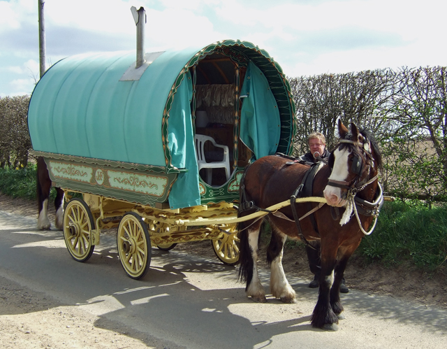
The closest that we've got is a comment, from a reader in one of my earlier blog entries. He said that his father called one of the Landywood Great Stones a gypsy's cook stone. That did check out. The Great Wyrley Review, produced by the Great Wyrley Local History Society (2011), includes a note that Gypsy caravans were parked in Holly Lane in 1958. The council tried to evict them, but they refused to go. More caravans arrived and it was quite the drama at the time.

They aren't there now, but maybe it left a vague memory in his father's mind, which became associated with the stone that remains there. Or maybe the Travellers did use it to cook or serve food on, back in the 1950s.

The Landywood Great Stones Were Not Wyrley's Stonehenge

Having hunted through the entire history sources at both Great Wyrley and Cannock Libraries, plus Paul Ford having searched Walsall Local History Archives, there is little to suggest that the Landywood Great Stones were an ancient monument. At least they weren't a 'druidic temple' nor anything close to Stonehenge.

Next time, I'll tell you exactly what I think they were.

Monday, 21 November 2011

The Hunt for the Landywood Great Stones Part Seven

In part six, we worked out what seemed like the definitive position of the Landywood Great Stones in the 19th and early 20th century. However, something is bothering me about it.

Where Does the Evidence Place The Landywood Great Stones?

Somewhere between the end of the 18th century and the early years of the 19th, Essington Forest was felled. It was so drastically cleared for charcoal (then the land used for coal-mining) that all that remains of it is now called Essington Wood.

It is currently believed that where Essington Forest met the modern day Holly Lane, the Landywood Great Stones originally sat. But they were moved under this industry to be dumped alongside Gorsey Lane.

19th century maps and an eye-witness from Great Wyrley all place them at the modern junction of Poplar Road and Gorsey Lane. Here is that view from Poplar Road:


View Larger Map


This position would make sense too, as it's downhill from Holly Lane. The stones could easily have been loaded behind a horse and dragged there. This 19th century position doesn't need to have any major relationship with the landscape. It was little more than a rubbish heap, from the point of view of those taking the stones there.

It appears cut and dried. But I still have my doubts.

Why the Landywood Great Stones Might not Have Been on Gorsey Lane

My problem is the photograph, which was produced by EJ Homeshaw and used in The Story of Bloxwich.


If the Landywood Great Stones were arranged in that arch position facing Gorsey Lane, then two aspects are immediately wrong. The first is that it's too close. The junction space touches Gorsey Lane itself, but that row of houses in the photograph is further away. Secondly, Poplar Cottages, just over the road, would have been there in the 1950s. They aren't shown in the photograph.

Moreover, the caption reveals something else very wrong. We are supposed to be able to see Barr Beacon, Druid's Heath and Cannock Chase from that position. Cannock Chase - check! There are few places in Great Wyrley where that forest can't be seen on the horizon. The sheer elevation of Wyrley Bank itself ensures that. This is also true of the junction of Poplar Road. By looking straight down Gorsey Lane, there is Cannock Chase in the distance.

But even accounting for the presence of modern housing, anyone standing there would struggle to see Barr Beacon or Druid's Heath. The slope of Broom Hill is in the way. Gorsey Lane was built to go around much of this hill, while also climbing into Landywood. By placing the Great Stones down there, much of the view described by Homeshaw is lost. Yet this is what he was seeing in 1951.

Problems with the Landywood Great Stones Facing Wharwell Lane

I puzzled this out, particularly what I had been told by Steve. He had seen them roughly at the junction of Poplar Road, before the Tower View council estate had been built (and therefore before Poplar Road even existed). I had duly noted that without asking one pertinent question of him: which junction of Poplar Road?

I had made a huge assumption, based on the fact that the 1888 map clearly places the Landywood Great Stones alongside Gorsey Lane. They are roughly in the position where it now meets Poplar Road. I thought that Steve was just confirming this.


He could well have been. That map does show a kind of arch motif, but facing towards Wharwell Lane. If so, then the terraced houses in the background would certainly be those houses. The photographer would basically be standing on Gorsey Lane, with their back to Poplar Cottages. There would be a slight elevation, from that angle, so the background of the photograph would match everything else that we know.

Except that we still wouldn't be able to see Barr Beacon and Druid's Heath from there; and we're assuming that the houses in Wharwell Lane were terraced then, because they aren't now.

Were the Landywood Great Stones Were at the Other End of Poplar Road?

Poplar Road starts halfway down Broom Hill and climbs to its summit. There it meets Fairoaks Drive and the view is impeded by a lot of mid-20th century houses. These did not exist when Homeshaw was taking his photograph.


View Larger Map


Steve had said that a patch of land had not been built at the junction where the Landywood Great Stones stood, because the original plan was for them to be replaced. The bungalow, on the right-hand corner, has a much bigger garden than any home in that area. It's also in an arch shape.

This junction, between Poplar Road and Fairoaks Drive, would have afforded a view of Cannock Chase to the north and both Barr Beacon and Druid's Heath to the south-east. That's not possible now, because of the houses on the east side of Fairoaks Drive.

Moreover, if we leapfrog over these houses and visit the Walsall Road, directly behind them, we find precisely the terraced houses for which we were looking.


View Larger Map


In short, a position at the other end of Poplar Road fits perfectly with the view that Homeshaw was describing and photographing in 1951. Neither does it contradict what Steve told me (and how I'm now kicking myself for not clarifying that at the time!). However, this position contradicts that given in the 19th century maps.

Were the stones moved twice before being scattered? Or are we simply looking at Wharwell Lane; and there was a view through Broom Hill, that isn't obvious when it's covered with houses? If any Wyrley people know, I would love to hear from you!

Friday, 18 November 2011

The Hunt for the Landywood Great Stones Part Six

Every great quest eventually has to involve an encounter with a white-bearded man, who casts light on the journey. Arthur got Merlin; Bilbo and Frodo got Gandalf; Harry Potter got Dumbledore. I got a bloke called Steve. His beard wasn't entirely white, but nevertheless I certainly knew where to slot him into this particular legend.

In part five, we learned all that the local archives could tell us about the Landywood Great Stones (not much). Now it was time to firmly locate two of them.


How Big Were the Landywood Great Stones?

Nowhere in the history books had the actual size of the Landywood Great Stones been mentioned. Their name implies something magnificent. Homeshaw and Sambrook had called them a 'temple of the Druids'.

Cllr Williams had asked around and duly informed me, "We're not talking small here. These were big, massive things." But she also counselled that this was hearsay. She had never seen them for herself, other than the existing stone beside Landywood Enterprise Park. This, she had been told, was one of the smaller stones.

Most people would be forgiven for imagining something on the scale of Stonehenge by now. But we had evidence. We had a photograph and we had a stone that was in that photograph. It would be a simple case of matching up the two, then getting out the tape measure. The rest could be extrapolated from that.


Rejoice in my amazing Paint skills!
Then note that the red lines are meant to indicate a circumference.

Historical Research: Not Like Indiana Jones

Of course, I chose to do this during the school run, thus attracting the attention of several parents walking down to Landywood Primary School, just around the corner. A short pause and then I had another audience of parents AND their young off-spring.

Conscious of my onlookers, I tried to make my historical research look as much like Indiana Jones as possible. Which was a bit hard, when I was using a tape measure in the shape of a bubble bee. I did answer several questions about the megalithic period and hoped my answers were pitched at the right level. I also pointed out the shape of Holly Lane to a few interested youngsters and parents. While reassuring one anxious father that I really wasn't from the council and no, I wasn't doing this with a view to removing the stone.

Landywood Great Stones: Enter Merlin

I had deep suspicions before even arriving that this purportedly small stone was actually one of the larger stones in the black and white photograph.


Now I was there, I was sure; but I also thought that the stone was now upside down. I needed the right camera angle to work this out. So I was lying flat on my back on a manhole cover, with my knees akimbo and a camera poking through the gap, shooting great images like this:


When a voice piped up, "Now I know what I look like, when I'm taking pictures of trees and rocks and the like."

I felt that some explanation was clearly needed, so I started on the speil that I'd practiced on all of those little children. I indicated the notebook lap-top lying beside me on the ground, with the 1951 photograph showing the Landywood Great Stones.

"I know," said Steve, "I've got the book. It's that one." He pointed to the stone that I'd been looking at all along. It turned out that Steve had lived in Great Wyrley all of his life. He could remember when the Tower View council estate didn't exist and when schoolboys had done cross country running over Broom Hill. "But this used to be the base." He encircled the stone and patted one of the surfaces. In this photograph, this original base is now on the right-hand side, bowling slightly inwards.


I was jubiliant! That was precisely the angle that I'd determined to be the bottom! The stone was upside down, but it was definitely the one in the photograph. "They used to be where the junction of Poplar Road and Gorsey Lane is now."

Then Steve added, "You know that there's another of the stones under the hedge over there, don't you?"

The Second Landywood Great Stone is Found

To be honest, I did kind of know. I'd found it on that first meander around the lane and thought it quite precisely placed for just a random stone. However, I was still under the impression that I was looking for something awe-inspiring in its megalithic majesty, like a poor person's Stonehenge. So I'd snapped a couple of pictures for later consideration, then promptly forgotten about it.


Now that I knew the true size of the stones, I had no doubt that Steve was correct.

The Position of the Landywood Great Stones

Poplar Road/Gorsey Lane junction, Great Wyrley. The grass verge still arches around where the Landywood Great Stones once stood during the 19th and early 20th centuries.


View Larger Map


Steve suspected that the builders were asked not to construct anything on that spot, as it was believed that the stones would be replaced. But once the houses were built, a decision was taken not to put them back. Instead they were scattered into their current positions.

So far that definitely includes two back in Holly Lane and the rest carted onto the Streets Lane estate. It was looking increasingly likely that they were those in a ditch opposite Chillington Close.

Wednesday, 16 November 2011

The Hunt for the Landywood Great Stones Part Five

In part four, Paul Ford of Walsall Local History Centre, provided us with a photograph of the Landywood Great Stones. It was time to hit Great Wyrley's archives too.

A Visit to Great Wyrley Library's Local History Section

'Wyrley grew through the centuries as the trees of the Cank Forest were cut down and the wastes were cultivated. Little remains now of the glory of the forest, but in the Old Gosse Field in Hazel Lane there is a copse of oak trees which, on a summer's day, give in miniature what the whole parish looked like in those days, when the Great Stones of Landywood stood overlooking the valley of Wyrley Brook, and constituted the temple of the Druids.'
A Plesance Great Wyrley 1051-1951

At least the book's spine and ASIN registration says that the author was A Plesance, but a glance at the back page reveals that the history is a reprint. It was reproduced for a local history exhibition in 1967, with permission granted by the widow and son of the original authors.

It is our old friend EJ Homeshaw (here named James Homeshaw) and Ralph Sambrook who did all of the research and writing. In July 1951, they had persuaded Great Wyrley Horticultural Soceity to publish this history for them. They are the real authors of Great Wyrley 1051 - 1951.

This was a great relief, as the same book also included, with precisely the same caption and type-face, EJ Homeshaw's photograph of the Landywood Great Stones from The Story of Bloxwich.

That would have been some thoroughly unashamed plagiarism (beyond the cheekiness of Mr Plesance for claiming authorship merely of a reprint) if that hadn't been the case!

Despite a thorough search through the large collection of local history sources, in Great Wyrley Library, there was little more to tell. Two writers in the 1950s had believed the stones to be Druidic - thus presumably placed there by the Celts back in the days when Wyrley was part of modern day Powys; ruled over by the Cornovii.

I wrinkled up my nose. I would want a lot more evidence than that to implicate the Celts. By the time they reached Britain, most of the standing stones and circles had been withstanding the British weather for at least a 1000 years. Which isn't to say that my ancestors didn't use them in their religious rituals, so maybe Mr Homeshaw and Mr Sambrook had a point after all. We'll call this 'not proven' for the moment. I will return to the issue in a later blog entry.

Landywood Lost Beneath Essington Forest

The only other item of interest was an 18th century map, which appeared to show the vast Essington Forest encroaching down to Gorsey Lane. It was impossible to tell from the scale whether Gorsey Lane ended at its present day junction, or if the forest went on further still. But something was patently clear - there was no Holly Lane.

The mention of the stones, which had set me on the trail of them, had stated that Holly Lane looped around their original position. I brushed off my latent artistic talent (stop laughing) to produce that here:


The map that I now consulted had been charted between 1734-1798, which made precision pin-pointing a little vague. Nevertheless whenever the cartographer had walked through, there had been no Holly Lane, just Gorsey Lane ending at the edge of the forest. Moreover, the contours of said forest looked suspiciously like the modern day shape of Holly Lane.

Was the road created when the forest was felled for charcoal, then dug up for coal? Highly likely. Particularly when we consider that the lane provides access to the coalfields of under and around today's Streets Lane estate, as well as to the canal built to take coal to Wolverhampton. I could also hazard a guess at the type of trees most common at the edge of Essington Forest...

Were the Great Stones Ever Near Holly Lane?

It's tempting to dismiss the local legend that the Landywood Great Stones were ever in that Holly Lane loop. But that may be too premature.

The story went that the stones were removed because of coal-mining. That is precisely why Essington Forest disappeared and why that area is still an expanse of fields. Also, why did the forest bulge out at that exact point? Those clearing the trees to its 18th century edges obviously had something they wanted to skirt, or else the forest contour would have been perfectly straight.

The second part of the story is that the Great Stones were dragged to a ditch in Gorsey Lane and dumped there. This also makes sense, because the 18th century map reveals that Gorsey Lane was the only track in the vicinity.

The photograph, from 1951, clearly places the stones on a hill. The 19th century maps show this as Broom Hill (under the Tower View housing estate, as modern Wyrley folk would know it). It's hard to imagine them getting there accidentally; and easy to see why local historians concluded that this was a Druidic temple. But for one pertinent fact: Broom Hill wasn't the highest point in Great Wyrley.

From Holly Lane, you actually have to go downhill into the Tower View Estate. Gorsey Lane slopes steadily from Landywood all the way to the Quinton Estate. Wharwell Lane slopes even more steeply towards the Walsall Road. In short, the proposed original position, in that loop of Holly Lane, is the highest point in the area.

Which still doesn't mean that the Druids put them there; but if any megalithic human beings did, then the Holly Lane loop remains the most likely original position in the area.

'Would our interest in history have been greater had we known that... the stones lying in an untidy heap in the corner of a field at Landywood were older than the Romans themselves?'
James Homeshaw and Ralph Sambrook, Foreword
in A Pleasance 'Great Wyrley 1051-1951'

Monday, 31 October 2011

The Hunt for the Landywood Great Stones Part Four

In part three, we explored the relocation of the Landywood Great Stones to the Streets Lane estate area. Now a reader has supplied some extra evidence from their original location.

Landywood Great Stones in History of Bloxwich

In 1955, Ernest James Homeshaw published his The Story of Bloxwich. It since went out of print, but was republished by Walsall Metropolitan Borough Council Library and Museum Service. The 1988 Reprint of The Story of Bloxwichis difficult to find and expensive to buy, though there is a copy in Walsall Library.

However, thanks to Paul Ford of Walsall Local History Centre, we can see an original picture of the Landywood Great Stones from Homeshaw's book.


In case that caption is a little small, it reads: 'The Great Stones of Landywood. From the top of the hill where they lie, Barr Beacon, Druids' Heath, and the panorama of Cannock Chase may be viewed.'

Where Were the Great Stones in Homeshaw's Photograph?

Ernest Homeshaw wrote that the Great Stones of Landywood were on a hill. The place beside Holly Lane, where they reputedly originally stood, is flat. However, the area beside Gorsey Lane, where they were moved, was called Broom Hill.

This undoubtedly had the kind of view which Homeshaw described. In 1642, the Roundheads camped upon Broom Hill, during the English Civil War. They were there long enough to dig a well, which still remains, hidden under foliage, in Wharwell Lane (War + well). It can only be expected that an army would take the higher ground. However, the hill itself has now been flattened to make way for a council estate there.

Moreover, it has already been established from old maps that the stones had been moved to Gorsey Lane by 1888. This is probably where Homeshaw's photograph was taken, with the houses in the background belonging to either Gorsey Lane, Wharwell Lane or, at a push, the Walsall Road.

In part five, I will attempt to match the stones in the historical picture with those confirmed or suspected to be on view in Great Wyrley today.

With thanks again to Paul Ford for all of his assistance.

Friday, 7 October 2011

The Hunt for the Landywood Great Stones Part Three


In part two, we learnt that the Landywood Great Stones had been buried beneath Weston Drive, on the Streets Lane estate. There should have been nothing to see up there, but was this strictly true?

Landywood Great Stones: Intriguing Rocky Outcrop in Streets Lane

Weston Drive exists as a horseshoe shaped road, linked at either end by the long Streets Lane. It is on the Cheslyn Hay side of the railway track, but part of the Great Wyrley parish. This is a kind of No-Man's-Land, where all rates, bills and voting render the estate part of Wyrley, but the address states Cheslyn Hay. Just to confuse matters further, the roadsign welcoming visitors to Cheslyn Hay is half a mile up the road.

Until the dawn of the 1980s, this area was given over to coal-mining. A map from 1888 shows it strewn with shafts. It was infamously one of the sites of the Great Wyrley Outrages of 1903, when a pit pony was found slashed, roughly where Chillington Close meets Streets Lane. It is also at this point that an unusual feature can be found today - a scattered pile of large rocks.

Mining debris or more survivors from the Landywood Great Stones?


Local residents say that they've been there for at least as long as the housing estate. They are bigger than they look, as they are partially buried in the ground and covered in the fallen leaves of autumn. These stones are scattered now, but they used to be piled more completely on top of each other. Twenty years ago, children used to climb all over them, so it can only be assumed that the health and safety conscious last decade saw them separated into their present position.

Nobody I spoke with seems to know what they are. Though they are positioned at the head of a ditch, they don't appear to be anything to do with drainage. But if they are more survivors of the Landywood Great Stones, then those were much smaller than has been mooted.

For the moment, a question mark hangs over them, while I do a bit more research.


View Larger Map


Coming up in part four: An historical photograph of the Great Stones emerges.

Thursday, 6 October 2011

The Hunt for the Landywood Great Stones Part Two


In part one, I examined old maps of Great Wyrley looking for the legendary Landywood Great Stones. They had apparently existed, but where were they now?

Landywood Great Stones: Asking the Council

By now convinced that the Landywood Great Stones had existed (albeit still unproved in their original position), I sought out Councillor Kath Williams. As Great Wyrley's current local government representative, she should have access to its historical records. She asked me to leave it with her.

Good to her word, Councillor Williams returned my call a few days later. Conferring with a colleague, Kath Perry, she had discovered that the Landywood Great Stones had indeed once existed. They had been moved because of coal-mining and they had been scattered at the side of Gorsey Lane right up until the middle of the 20th century.

But this was a time of building, when council estates were being constructed all over Great Wyrley. The great stones were in the way, when houses were built on the north side of Gorsey Lane. They were removed to the Old Colliery, on the other side of the railway track. Then the Streets Lane council estate was created there. The Landywood Great Stones were too large to simply cart away again, so they were buried. They are believed to be underneath Weston Drive, off Streets Lane.

"We're not talking small here," Cllr Williams told me. "These were big, massive things."

Short of persuading every resident of Weston Drive to allow us to demolish their homes, the Great Stones will remain hidden.

Landywood Great Stones: The Sole Survivor on the Surface

However, one stone had survived on the surface. Much smaller than the rest, this had been used as a feature at the gate of Landywood Enterprise Park, on Holly Lane.


Cllr Williams was keen to emphasise that the size of the Landywood Great Stones could not be judged by this sole survivor. This one was chosen simply because it was relatively tiny.

It sits on Holly Lane, directly opposite to that large loop in the road, which is the supposed original site of the stones. If they were still there, then its narrower side would be pointing right towards them.
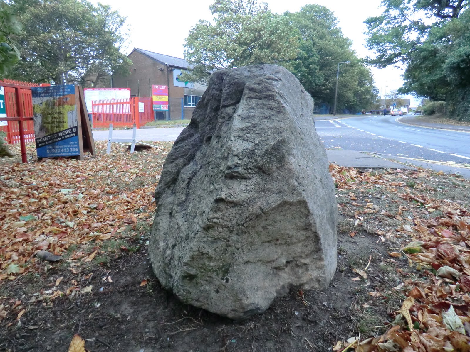
Update: WyrleyWolves has commented that he was told by his father that this was a 'gypsy cooking stone'.


View Larger Map


Coming up in part three: did more of the Landywood Great Stones survive?

Wednesday, 5 October 2011

The Hunt for the Landywood Great Stones Part One

The spot around which Holly Lane loops.

In a previous blog entry (History of Wolverhampton: The Standing Stones), I talked about how there had once been standing stones in Great Wyrley. There was a map, showing a kink in the road in Holly Lane, which was the only modern day evidence that the Landywood Great Stones had ever existed.

It was an intriguing mystery as to what they had looked like and where they had gone. One too fascinating for a mere historian like me to ignore.

The Landywood Great Stones: A Resident Recalls Their Existence

In August 2011, a resident of Great Wyrley named Bleakly wrote an entry at The Megalithic Portal website. (S)he referenced 'The Story of Bloxwich' by EJ Homeshaw in stating that a stone circle had existed in Landywood, now part of Great Wyrley. The stones had been moved, after World War Two, so that the land beneath could be turned into an open-cast mine.

Bleakly went on that there had been a photograph of it, 'in a pamphlet I have somewhere in my possession', but a copy wasn't forthcoming. There was also a personal testimony, 'I remember seeing them in the ditch along Gorsey Lane when I was a child but they were completely removed during the construction of a housing estate'.

These stones were located on the hill, near to the junction of Holly Lane and Gorsey Lane. When this area had been a forested heathland, then the Landywood Great Stones would have been visible from the Old Fort in Brownhills and Castle Ring in Cannock Chase.

Landywood Great Stones: Their Position on Maps

As the Landywood Great Stones contributed to the strange loop in the middle of Holly Lane, their original position is easy to identify on a map. This is one which dates from between 1831-1835:


Here is a close up of Holly Lane (coloured in blue) with the supposed position of the stones (circled in orange).


A pecularity, if the Homeshaw telling is accepted, is that the Great Stones are notable by their absence. This map has fine detail, marking even the position of houses, furnaces, public houses and collieries, yet no stone circle. This would be explicable if no other ancient monuments were included, but the Roman ruins of Letocetum are faithfully reproduced near Lichfield; Castle Old Fort is shown in Brownhills; and Dudley Castle is precisely where you would expect it to be. Tiny copses and brooks are named and noted, but not a stone circle in Landywood.

It would be easy to write them off as folk legend, but for the fact that they reappear again around 1888. But they aren't in Holly Lane.


In the intervening 50+ years, coal mines sprang up all over Great Wyrley, along with the railway line to serve them. If the Landywood Great Stones had ever been in Holly Lane, then they weren't moved after World War Two. They were already in Gorsey Lane by 1888. If that was due to coal-mining, then it would have happened in the mid-19th century.

A comparison between the 1830s map and that of 1888 does appear to show something marked in roughly the right spot, on Gorsey Lane, for the stones to have always been there. But the earlier one seems to be a house.

Moreover, Gorsey Lane changed course, straightening more directly between the junction with Holly Lane and the meeting with Hilton Lane. The partial levelling of Broom Hill allowed for that, as Gorsey Lane no longer had to bend so far around it.

The proposed earlier spot of the great stones, in Holly Lane, had become the Fighting Grounds of 1888.

Gorsey Lane today (with no Great Stones)

The search was on.

Part two: One of the stones is found.