Mr Wiggin is an older man. He comes from a family which has been in Great Wyrley for generations. When my mother asked him about the Stones, he knew immediately what she was talking about. She asked where they were located and he replied that they were opposite where Landywood Primary School now sits. They were in The Gosse.
The Landywood Great Stones in The Gosse
This rang a bell with me. Returning to our old friends, James Homeshaw and Ralph Sambrook, there was a mention of the Old Gosse Field, just before they discussed the Landywood Great Stones:
'Wyrley grew through the centuries as the trees of the Cank Forest were cut down and the wastes were cultivated. Little remains now of the glory of the forest, but in the Old Gosse Field in Hazel Lane there is a copse of oak trees which, on a summer's day, give in miniature what the whole parish looked like in those days, when the Great Stones of Landywood stood overlooking the valley of Wyrley Brook, and constituted the temple of the Druids.'
EJ Homeshaw and R Sambrook, in A Plesance Great Wyrley 1051 - 1951.
However this does leave me with a slight problem: Hazel Lane is nowhere near Landywood Primary School.
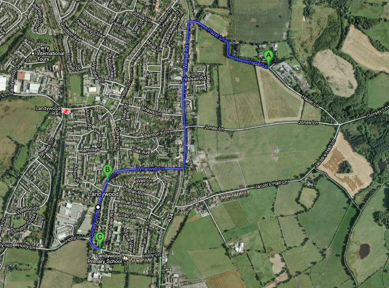
A = Hazel Lane, which is where Homeshaw and Sambrook placed the Old Gosse.
B = Poplar Road, which is where Steve and the 19th century maps placed the stones.
C = Landywood Primary School, in Holly Lane, opposite which Mr Wiggin placed both the Gosse and the Landywood Great Stones.
It should be remembered that each of these testimonies recall a time when none of the housing nor roads existed between B and C. When all four gentlemen were noting the position of the stones, they were looking out over a hill covered in gorse bushes, with fields beyond.
With his back to Landywood Primary School, Mr Wiggin could have seen the Great Stones in the distance opposite, if they were at the present day junction of Poplar Road and Gorsey Lane. Hazel Lane would have been too far away, with a hill obscuring the view, to be seen from there.
We are also assuming that 'opposite' means looking towards the Tower View estate on Broom Hill. There is, of course, a 360 degree view from that school. It is intriguing to note that the supposed pre-19th century position of the stones, in the Holly Lane loop, is also opposite Landywood School, if looking to the west.
My next priority is to a) discover the precise location of The Gosse; and b) track down Mr Wiggin and clarify the details that he told my Mum.
The Landywood Great Stones in the Muck Tip
Mr Wiggin's recollections didn't end with the Gosse. Mindful of the decade or so gap in my timeline, my mother asked him where the Landywood Great Stones went, after being moved from the Gosse.
He knew this one too and had an amusing story to add some colour. Before Landywood Enterprise Park was built, the site had been known locally as the Muck Tip. It was where the factory on Gorsey Lane dumped its waste, so a distinct slurry had formed there.
One night, Mr Wiggin and his brother had been to Blower's Club, in Holly Lane, with their grandmother. She was in a wheelchair. It was very dark, with just a gas lamp in the distance of Gorsey Lane to guide them. Perhaps it was the lack of night vision or maybe they'd partaken of a few too many beverages at the club, but they took a wrong turn. The merry group thought they were heading down Gorsey Lane, but they had really entered the Muck Tip.
Very soon, the front wheels of the chair hit something solid, propelling their old grandmother out of her wheelchair. She landed right in the slurry, plastered in the stuff. By all accounts, her grandsons were too busy laughing to immediately help her back into their chair. Fortunately for them, she also found the episode highly amusing. Filthy, but uninjured, she was eventually restored to her chair and the Wiggins found their way home again.
The relevance here is that this is where the Landywood Great Stones ended up too. Once they were removed from the Gosse, they were carted to the Muck Tip. There they presumably remained until Landywood Enterprise Park was built. One of them is still there, at the entrance as a decoration and curiosity. The rest were taken up the Streets Lane estate and either buried under Weston Drive or dumped at the side of Streets Lane itself.
A Recap of the Known Locations of the Landywood Great Stones
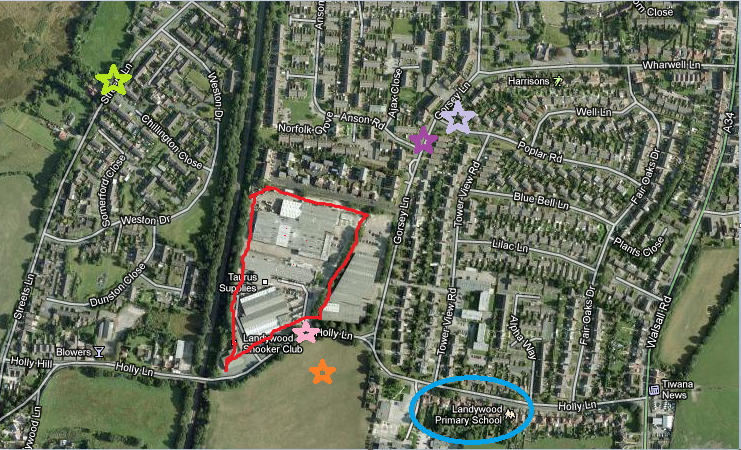
These stones moved around a lot, as industry, housing and businesses took priority of their sites. Here is a recap of where they are confirmed or suspected of historically being:
- Orange Star: Their supposed original, pre-19th century position in the loop of Holly Lane. They would have been surrounded by the trees of Essington Forest then.
- Lilac Star: Their position as shown on 19th century maps and remembered by Steve.
- Blue Circle: Their 20th century position was 'opposite Landywood Primary School' located in The Gosse, as recalled by Mr Wiggin.
- Red Bordered Area: In the mid-20th century, this would have been the Muck Tip. Mr Wiggin says that the Landywood Great Stones were briefly there. They were moved again, when construction started on the Enterprise Park in 1982.
- Pink Star: The position of one of the stones, which is still there today. It would have been placed there circa 1985, when Princess Diana came to open Landywood Enterprise Park.
- Lime Green Star: The place where I believe that remainder of the Great Stones were dumped. Cllr Kath Williams alternatively heard that the stones were buried under Weston Drive, which is close to that location.
- Purple Star: The position of the stones, in the ditch just north of where Anson Road meets Gorsey Lane, as told by Ruination in the comments to this blog.
I will share more information about the Landywood Great Stones as I learn it.


This tale is becoming quite a story isn’t it?
ReplyDeleteIt is quite, quite obvious where the stones ‘Stood’.
When I read that you had contacted a local politician in search of information, the story darkened and the truth became more distant.
The tale deepens and become more of a ‘tale’.
The Lilac star is too far north - the stones were opposite in the ditch just north of where Anson Road joins Gorsey Lane.
ReplyDeleteIt is quite a tale now. I quite enjoyed that little quest that you inadvertently sent me on!
ReplyDeleteI still have the feelers out, so even more information may come with time. But in the meanwhile, I'll update that picture with your own location. Thanks for that!
Addendum.................
ReplyDeleteJust South*** of where Anson Road joins Gorsey Lane.
:)