
Stonehenge: Not in Wolverhampton
There were people in and around the Wolverhampton area during the Neolithic. We know this because they brought megaliths here. A community would have had to come together to do it, because one person can't shift these standing stones on their own.
The first to arrive wasn't carried here by human engineering. In my previous blog, I mentioned that a huge, wild river once deposited all that 'Bunter' sandstone into our bedrock. The melting of the ice age might have caused that. As mile-high walls of ice dripped into thawing, mighty rivers were formed. One of them was strong enough to carve a massive monolith of felsite, from the vicinity of Arenig, Gwynedd. Imagine the force of nature necessary to carry that, all the way from west Wales, to where Oak Street, in Wolverhampton, is now.
View Larger Map
This standing stone is no longer in Oak Street. Wulfrunians belatedly got involved in moving it, in 1881, when they carted it off to West Park. It can be seen there now, with a little plaque on it, placing Arenig in its old county name of Merionethshire.
Outside St Peter's Collegiate Church, there is another interesting stone. Most people miss it, because it's behind the railings and hidden from the garden view by a large bush. Those who do spot it generally mistake it either for a gravestone or else excitedly believe that they are glimpsing evidence of Wolverhampton's Neolithic past.

In the days when Wolverhampton was getting rich off wool, the drovers would come down from the Welsh mountains to sell their sheep. (Some of them following the path of that great chunk of rock in West Park.) This wasn't the age of lawyers and contracts, it was a time of deals being struck with a handshake. In order that no-one reneged on the exchange, woolman and drover would walk off to Queen Square, where the stone used to sit. They would both place their hands through the hole in the stone and their handshake meant an unbreakable bargain had been made. To this day, it is called the Bargain Stone.
However, before you leave in disappointment at the lack of genuine Neolithic stones to see in the city, there is still some evidence that they were about. On the outskirts of Wolverhampton is Featherstone. The name means has nothing to do with things found on birds. Feotherestan was its 10th century name. Feother was 'four' in Old English. The 'stone' part speaks for itself.
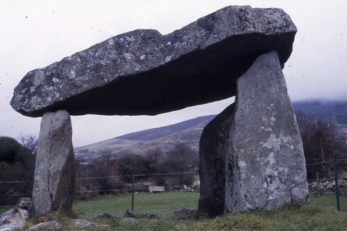
Ballykeel Dolmen - Did the Featherstone one look like this?
Scholars believe that there was once a tetralith (or dolmen) in the area. A tetralith consisted of three standing stones with a fourth balanced on top.
In 1971, a farmer named Mr Harper was digging a drain, on Brookhouse Farm, Brookhouse Lane, Featherstone. His shovel uncovered a 5,000 year old stone axe head. It's now in the Birmingham Museum.
Also, just over the modern day M6 from Featherstone, is Landywood, in Great Wyrley. Until living memory, there was a stone circle to the side of Holly Lane. During World War Two, the stones were removed to make way for open cast mining. They were just dumped in a ditch along Gorsey Lane. Later still, a housing estate was built and the Landywood Great Stones were taken away, never to be seen again.
View Larger Map
The only evidence that remains that they were ever there is a kink in the path of Holly Lane. It should be a straight line, but the road veers off, as if it is continuing into Gorsey Lane. Then suddenly, it reverts back onto its original line and carries on up to the forked junctions with Strawberry Lane and Streets Lane. That strange bend once took Holly Lane around the edge of the Great Stones, long before Gorsey Lane was even created.
As for the rest, unfortunately it's believed that the Industrial Revolution and the sprawling development, in the Black Country, destroyed all of our long barrows. The Neolithic sank, almost without trace, under the black smoke and coal that gave us our name.
No comments:
Post a Comment